Once weathered, I had some fun taking pictures of my new SP M-4 outside on the diorama. It's certainly not a California setting, but sunlight brings forward the qualities of this budget model. I wouldn't recommend it to die hard SP fan, but has a funny quick modelling project, it certainly paid off!
Friday, October 27, 2023
Refurbishing an IHC 2-6-0 - A 15 years Project
Once weathered, I had some fun taking pictures of my new SP M-4 outside on the diorama. It's certainly not a California setting, but sunlight brings forward the qualities of this budget model. I wouldn't recommend it to die hard SP fan, but has a funny quick modelling project, it certainly paid off!
Tuesday, October 17, 2023
Return to Monk Subdivision
Last September, when the fall colors were still subtle and subdued, I went to Bellechasse to hunt for backdrop pictures and visit a few spots I missed last time I followed the old National Transcontinental Railway roadbed.
It was one
of these strange autumn days when nights are cool and days are warm, generating
a deep fog that clings on hill and wood. This luminous and eerie ambiance was
perfect for a road trip yet a little bit less for backdrop photographs since
Appalachian mountains were virtually invisible to the naked eye even if they
were only a few miles away. That said, they were plenty of good opportunities
and I didn’t miss them when they shown up!
As
expected, railfanning the old NTR is a fool’s errand in the sense that there is
very little to see and most of the adventure is about driving long rural roads
dotted with colonization era farmhouses, crumbling barns and lost fields.
Forest is regaining its rights in these countries and soon, nothing will be
left to be seen. That said, I was for a great start when the main street
leading to Tourville (Monk station) gently curved around the calm and beautiful
Lac Noir (Black Lake). Serene and scenic, the lake reminded me I entered a
territory well known for being a sportsman paradise.
 |
| Lac Noir, in Tourville |
Tourville
was, as always, that sleepy town it has been since 1955 when the steam
locomotive shops were closed down. That said, while it’s no longer the vibrant
place it used to be, it’s still quite alive due to a renewed touristic
vocation. Taking the gravel road westward, my goal was to finally get a glimpse
of the causeway at Lac Therrien which was immortalized to vividly by the late
Richard Manicom back in 1963.
Google Maps
indicated a parking lot and a hiking trail leading to the Monk subdivision
under the pompous Tourville Nature Park which convinced me it would be
relatively easy to reach the roadbed… however, as is always the case, the
parking lot was inexistant and the hiking trail was long lost to nature. My
only choice was to park the car by the ditch and walk a muddy ATV trail. Since
it was the beginning of hunting season, I wore my bright orange pullover, but
it didn’t feel safe to walk there alone! But Monk always reserve surprises and
after a while, the muddy path was consolidated by using wood planks… or should
I say, old railway ties. Unmistakably, the roadbed was nearby and sure it was.
NTR ties are always found where you least expect them
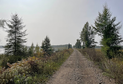
I climbed
the gentle slope of the fill then found myself in the middle of a long straight
corridor lined with conifers until it vanished into the horizon on both side.
That was the hallmark of NTR exacting standards of construction applied in the
most remote areas. On the right, toward Tourville, I could see a break in
scenery that was the old bridge over the lake discharge. Under normal
circumstances, I would have taken the Nature Park trail up there, but that
would be for another time. I turned on my left and walked for about 500m until
I reached the old causeway.
The causeway reveals itself after a short walk
In any
circumstance, there is nothing exceptional about Lac Therrien. It’s one of
these thousands of similar lakes that can be found everywhere in Canada, yet
that’s why it’s interesting because it’s such a classic sight. At that point,
as was common with railway building practices of the time, the roadbed was built
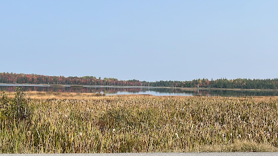
at the boundary between the lake and the marshes. In early Autumn, the marshes
were covered in a beautiful array of colors ranging from various greens to
yellows. Straw color, brown and reddish hues completed that mundane yet subtle
landscape painting. In the middle of nature, nothing could be heard and a
peaceful feeling filled the place.
A large marsh lies north of the causeway
After
meeting a few peoples on ATV, I started to explore the causeways and soon, details
started to pop up. I was looking for a small steel deck bridge over the creek,
but was welcomed by a concrete culvert. At some points, big lumber were added
to the original structure to widen it. But at the time of my visit, they were
crumbling and sliding down the causeway. Nevertheless, I went down and stood on
them to get a better glimpse of the culvert. It was quite obscured by the
fallen lumbers, but a quick examination shown the concrete was in perfect
condition after all these years. Better, a built date could be still read on
the span: 1913, which was consistent with the first year of operation under
Intercolonial Railway care in 1914.
This culvert was built in 1913
Nearby in
the dark stagnant water of the marshes was a straight stump from a tree, but
that also revealed itself to be the remnant of a telegraph pole. I would
discover later that is was common practice to install the lines right in the
water when crossing water courses on the NTR. I then proceeded to shoot several
panoramic pictures with the goal of replicating that neat scenery on the home
layout. When walking back to the car, I was tempted to walk another 1.5km to
reach the other bridge, but decided to postpone that trek due to active hunters
and a sun that was going down faster than I thought.
An old telegraph pole blending into the landscape
Driving on
the country roads, I could see the fog starting to gather faster than I thought.
I stopped in several places to shoot typical Appalachian landscapes, but I
perfectly knew most of them would be unusable. When I reached Ste-Apolline-de-Patton,
you could have bet a wildfire was in the area.
 |
| Atmospherical fog layering Ste. Apolline's landscape |
From that
point on, I decided to change my plans and drive to Armagh as fast as I could.
In Ste. Euphémie, I tried to shoot the classic Ken Goslett scene, but trees had
completely obscured the sight and it was no longer possible to replicate it.
The concrete culvert was barely visible, yet the old houses and barns were
still standing.
In Armagh,
road construction blocked the main route and I had to take a rickety detour which
yielded a couple of nice panoramas that could have some use on the layout. So,
when I thought my trip was just a fun autumn ride, it finally provided some
results. It was time to go back home before the sunset.
It was the
third time I visited Monk Subdivision and it left the same weird feeling about
the NTR. The malaise of seeing such beautiful track standards but serving
almost no tangible goals, except political ones, is quite strange. A weird mix
of being baffled by a nonsensical piece of work yet astounded by the skills and
resources poured into it. I’m not done
with the NTR in Quebec and will need to revisit it again and again to make
sense of that Transcontinental that could have been…


